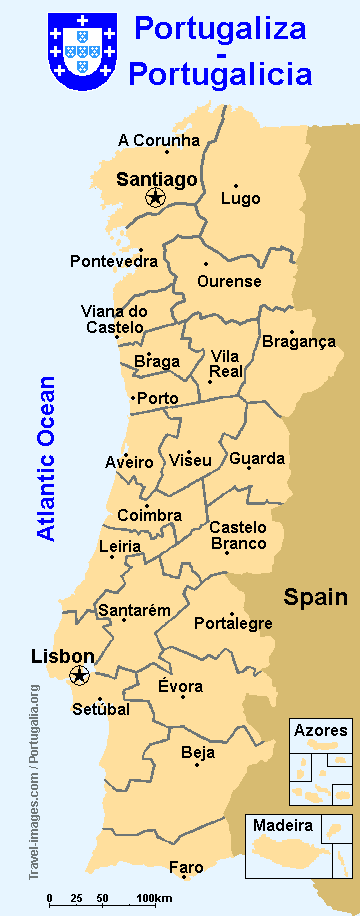
Map of Portugalicia - Mapa da Portugaliza |
Geography: Portugalicia is continental
Europe's westernost nation. The territory is roughly rectangular, with
a long Atlantic coast on the Atlantic on the Northern, Western and Southern
sides. The east borders Spain. Continental Portugalicia shares the Iberian
Peninsula with Spain, Catalonia, Aragon, Euskadi and Andorra. Besides the
20 contiguous continental districts Portugalicia also includes the Azores
and Madeira archipelagos (in the Atlantic).
Total area: 121,929 sq km Highest point: Pena Trevinca mountain (2 124 m) on the Serra do Eixo, Ourense (42° 14' N; 6° 48' W) Population: 13.700.000 (2007, est.) Currency: Euro Part of the European Union GDP: 255 billion Euros (2006 Estimate) Languages: Galician-Portuguese with Castilian minorities in the Lugo, Ourense, Pontevedra and A Corunha districts. Founded: 410 A.D. (Kingdom of Galicia) Territorial disputes: with Spain regarding control of the Olivença and Táliga municipalities (Évora), western part of O Bierzo and Terra Eo-Navia (Lugo) and As Portelas (Ourense). Time zone: UTC / UTC +1 (DST) Capitals: Santiago de Compostela and Lisbon |
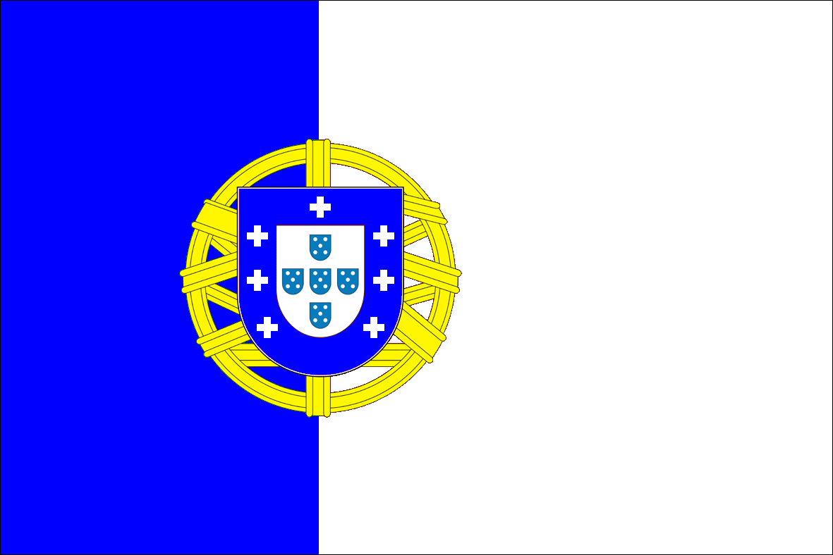
The Portugalician flag is a 2:3 rectangle (i.e. length is 1 ½ times the width) divided vertically into intense sky blue at the hoist (2/5 of the flags length) and white at the fly (3/5). Over this partition is the Portugalician coat-of-arms.
Portugalician coat-of-arms:
Blue Escutcheon with white inescutcheon. The outer area (bordure ) includes seven white crosses, one of them on the chief portion, representing the 7 heads of the old Kingdom of Galicia. The central part displays a compound greek cross of five light cobalt eschuteons (escudetes or quinas) each with 5 white / silver bezants. The 5 eschuteons stand for the five Muslim kings defeated in the battle of Ourique and the 5 bezants represent the five wounds of Jesus Christ on the cross.
The Escutcheon rests over a yellow / golden Armillary Sphere, aligned along the flag's partition. This was an astronomical and navigation instrument made of wood or metal rings (armilas) interconnected around a central axis to form parallels, meridians and the ecliptic, allowing the calculation of a ship's position on the earth surface by examining the stars. It represents Portugalicia's global role in the age of discoveries. The armillary sphere possesses five arcs representing the ecliptic, the equator, two parallels (the tropics) and one meridian, all bearing embossed edges. The sphere has a diameter equal to ½ width and is equidistant from the upper and lower edges of the flag.
How to fold the Portugalician flag:
The flag should be folded into a square
centered on the coat-of-arms.