
| Nagorno Karabakh |
Azerb.com
|
Meaning
'Mountainous Black Garden' (the Armenians prefer the name 'Artsakh', the
ancient Albanian name), formerly an autonomous region within Azerbaijan,
the Nagorno-Karabakh (Daqliq Qarabaq) and some adjoining territories are
currently outside the control of the Azeri Government (see
international
disputes), and the former local Azeri population has been deslocated
eastwards.
 Nagorno-Karabakh,
with a population of 130.000 currently enjoys de facto, although
not de jure independence, however the long term goal of the Armenian
population it to re-join Armenia proper, as Artsakh's flag so well illustrates.
Nagorno-Karabakh,
with a population of 130.000 currently enjoys de facto, although
not de jure independence, however the long term goal of the Armenian
population it to re-join Armenia proper, as Artsakh's flag so well illustrates.
The language is a dialect of Armenian, with a lot of Russian borrowings. Although the region itself has an area of just about 4.400 sq. kms, the Nagorno Karabakh government controls a total of about 14.000 sq. kms. Only the eastern fringes of the Xocavand/Martuni and Martakert districts are under Azeri control.
 Some
of the formerly Azeri populated areas, in particular around the strategic
city of Lachin, have been re-settled with Armenian population (mainly refugees
from Azerbaijan). The international community still considers the entire
area as part of Azerbaijan.
Some
of the formerly Azeri populated areas, in particular around the strategic
city of Lachin, have been re-settled with Armenian population (mainly refugees
from Azerbaijan). The international community still considers the entire
area as part of Azerbaijan.
In terms of administrative divisions Azeris
and Armenians also don't agree, so you will find two visions of Nagorno
Karabakh:
|
|
|
|---|---|
|
|
|
|
|
|
|
|
|
|
|
|
|
|
|
|
|
|
 Mountain
ranges with summits up to an altitude of 3.724 meters (Mount Gyamysh),
form a rather complex pattern which gradually descends to the east until
it ends in the plain cheek of the steppes cut by the River Kura [Kour for
the Armenians] and some of its tributaries. The higher parts of Karabakh
are completely devoid of vegetation. Fogs are frequent and the upper peaks
and valleys are often lost in clouds, but the abundant rain makes possible
the growth of fine crops of grain and provides excellent pasturage for
the region's numerous herds.
Mountain
ranges with summits up to an altitude of 3.724 meters (Mount Gyamysh),
form a rather complex pattern which gradually descends to the east until
it ends in the plain cheek of the steppes cut by the River Kura [Kour for
the Armenians] and some of its tributaries. The higher parts of Karabakh
are completely devoid of vegetation. Fogs are frequent and the upper peaks
and valleys are often lost in clouds, but the abundant rain makes possible
the growth of fine crops of grain and provides excellent pasturage for
the region's numerous herds.
 Trees
are few here - birchwood and lapine meadows predominate. Even in summer
the nights are cold and the damp is always penetrating. In the lower valleys,
however, sheltered from the winds by the higher ranges and well watered
by the mountain streams, vegetation is luxuriant. Dense forests of oak,
hornbeam, and beech decorate the land. Wheat grows in abundance, vegetables
and cotton are raised as well, and huge walnut trees are almost lost in
the profusion of vines which cover them.
Trees
are few here - birchwood and lapine meadows predominate. Even in summer
the nights are cold and the damp is always penetrating. In the lower valleys,
however, sheltered from the winds by the higher ranges and well watered
by the mountain streams, vegetation is luxuriant. Dense forests of oak,
hornbeam, and beech decorate the land. Wheat grows in abundance, vegetables
and cotton are raised as well, and huge walnut trees are almost lost in
the profusion of vines which cover them.
To permit maximum utilization of every scrap of land, the houses tend to be terraced up along the mountain sides, while other terraces, held up by rough stone walls, serve to increase the area under cultivation. Elaborate irrigation systems have been devised by the villagers to divert the waters of the mountain stream to insure proper watering of the crops.
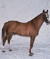 Set
in such a rugged, mountainous area, the Nagorno-Karabakh economy is based
largely on agriculture (including cattle, vineyards, orchards and mulberry
groves for silkworms) and copper mining. It his home to the famous Karabakh
horse.
Set
in such a rugged, mountainous area, the Nagorno-Karabakh economy is based
largely on agriculture (including cattle, vineyards, orchards and mulberry
groves for silkworms) and copper mining. It his home to the famous Karabakh
horse.
Although Azerbaijan imposed an economic blockade, the economy has improved dramatically after the end of the war, trade with Iran is brisk and services run smoothly (Iranian trucks are a common sight in the region's roads). Telecommunications work well and there is internet access.
 The
Armenians have steadily developed the apparatus of statehood: government
ministries scattered around Stepanakert with neat nameplates in English,
Russian and Armenian; passports and entry visas; a parliament with 33 democratically
elected representatives; and there is even a Miss Artsakh beauty competition
- bathing costumes and all - every April in the Palace of Youth. It seems
the only thing in the Republic of Nagorno-Karabakh does not have is a national
airline. The last passenger plane to fly into Stepanakert airport was shot
down by the Azeri forces (the airport is near Khodjaly).
The
Armenians have steadily developed the apparatus of statehood: government
ministries scattered around Stepanakert with neat nameplates in English,
Russian and Armenian; passports and entry visas; a parliament with 33 democratically
elected representatives; and there is even a Miss Artsakh beauty competition
- bathing costumes and all - every April in the Palace of Youth. It seems
the only thing in the Republic of Nagorno-Karabakh does not have is a national
airline. The last passenger plane to fly into Stepanakert airport was shot
down by the Azeri forces (the airport is near Khodjaly).
The region uses the Armenian dram
as its currency (1 dram= 100 luma, 1 Euro approx. = 500 dram). Dram
notes are printed in denominations of AMD5000, 1000, 500, 200, 100, 50,
25 and 10. Coins are in denominations of 50, 20, 10, 5, 3, 2 and 1 luma.
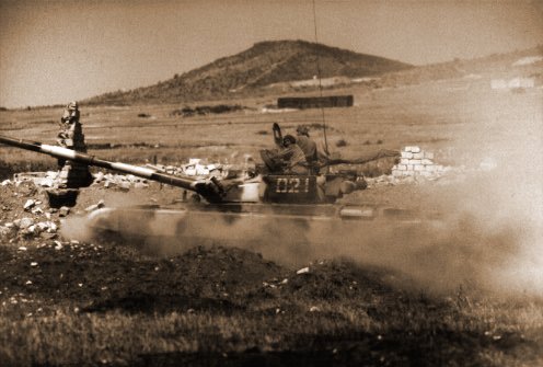 The
frontline between the armies of Azerbaijan and of Nagorno-Karabakh has
an air of permanence. The Armenian trenches, bunkers and earthworks are
well dug and reinforced with concrete posts, wooden palings and empty ammunition
boxes. A network of wire fences and minefields separate the two armies
who watch each other warily through binoculars across a kilometer of No
Man's Land. There are regular exchanges of sniper fire and large quantities
of men and material have been committed to holding this line. Behind the
lines of infantry trenches, a deep tank ditch has been excavated.
The
frontline between the armies of Azerbaijan and of Nagorno-Karabakh has
an air of permanence. The Armenian trenches, bunkers and earthworks are
well dug and reinforced with concrete posts, wooden palings and empty ammunition
boxes. A network of wire fences and minefields separate the two armies
who watch each other warily through binoculars across a kilometer of No
Man's Land. There are regular exchanges of sniper fire and large quantities
of men and material have been committed to holding this line. Behind the
lines of infantry trenches, a deep tank ditch has been excavated.
The Nagorno-Karabakh army is about 20.000 strong and it's trained at Ivanovka, just outside Xankandi. There is a two-year mandatory military service for males ages 18, but a good proportion of the army is professional. Training focuses not only on conventional warfare but also in guerrilla tactics.
Xankandi, the capital is a recent city, currently with a population of under 50.000 souls, slightly less than in Soviet times. It was founded in 1917 after the October revolution on the site of the village of the same name and was renamed Stepanakert in 1923 for Stepan Shaumyan, a Baku Armenian communist leader. After Azerbaijan gained independence the name was changed back to Xankandi, though the Armenians continue to call the city Stepanakert.
Due to the present military situation, to visit Xankandi you need to go via Armenia (this is quite easy, but see the visas section for details on the bureaucracy). The roads have been improved during recent years and new roads were also built. The road distance from Yerevan is about 200 km, so in the Armenian capital simply board a bus or rent a car. The road will take you via Goris, Lachin and Shusha, and plenty of breathtaking landscape.
As a more expensive, but faster, alternative you can get helicopter services between Yerevan and Xankandi (flights operated by Russian built Mi-8s).
(350 km west of Baku)
..
| see also: Xankandi/Stepanakert, hotels in Xankandi, maps, images, visas, Shusha, Agdam, Lachin, summary, history |
|
|
| A to Z of Azerbaijan / A dan Z ye Azerbaycan |
www.azerb.com
|