
| Terter (Tartar, Mir-Bashir) |
Azerb.com
|
Terter
is a tense place, due to the heavy military presence that comes with its
proximity to the Azeri-Armenian cease-fire line. The small town heads the
rayon (district) of the same name. Since its establishment in 1930 and
up to 1949 the district was called Terter. In 1963 it was amalgamated to
the neighbouring Barda district, later in 1965 it was again turned to a
separate administrative entity, this time renamed to Mir-Bashir.
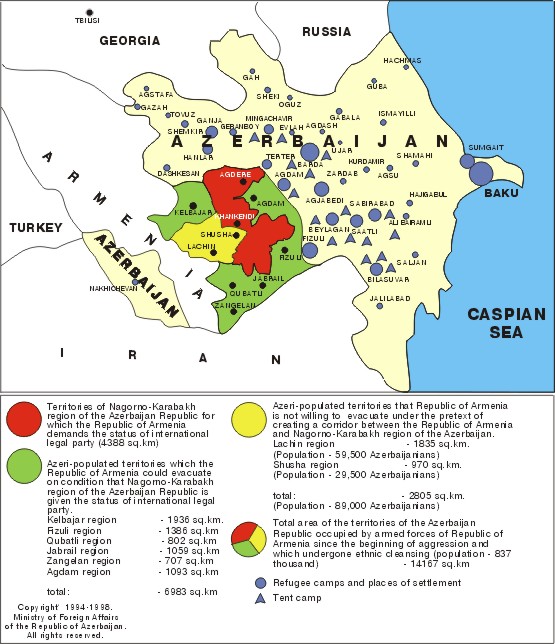
Terter district covers an area of 412 sq. km., situated in the lower course of the Terter river. In the north it is limited by the Injaget, and in the south by the Khachen river. It borders with NK, and Goranboy, Yevlakh, Barda and Aghdam districts. In the medieval period the entire area of the district was included into the Barda province. Afterwards, before the middle of the 19th century it entered into the Barda-Basan province.
 The
Terter district is part of the vast plain extending to the south and southeast
of Nagorno Karabakh and limited by the Kura and Arax rivers. It was
a prosperous Christian area of Caucasian Albania until the arrival of Arab
armies.
The
Terter district is part of the vast plain extending to the south and southeast
of Nagorno Karabakh and limited by the Kura and Arax rivers. It was
a prosperous Christian area of Caucasian Albania until the arrival of Arab
armies.
Since the 14th century the area was mostly populated by various Turkish nomadic tribes, that used the vast and warm plain as wintertime pastures. The Russian Czars promoted agriculture, irrigation works and the settlement of Russian colonists.
To this day the economy is based in agriculture, with the production and processing of cotton, silk, poultry and dairy products.
There are many refugees in the area, as well as relief agencies. Tourists are non-existent. Be careful if using cameras as police and army may give you a hard time. There is an archaeological site just outside town and 3 interesting churches in the northern part of the rayon.
(260 km west of Baku)
| see also: places, photos, Agdam, Naftalan, Barda, Yevlax, summary, maps, visas, history |
| A to Z of Azerbaijan / A dan Z ye Azerbaycan |
www.azerb.com
|