
| Transportation - Azerbaijan |
Azerb.com
|
|
|
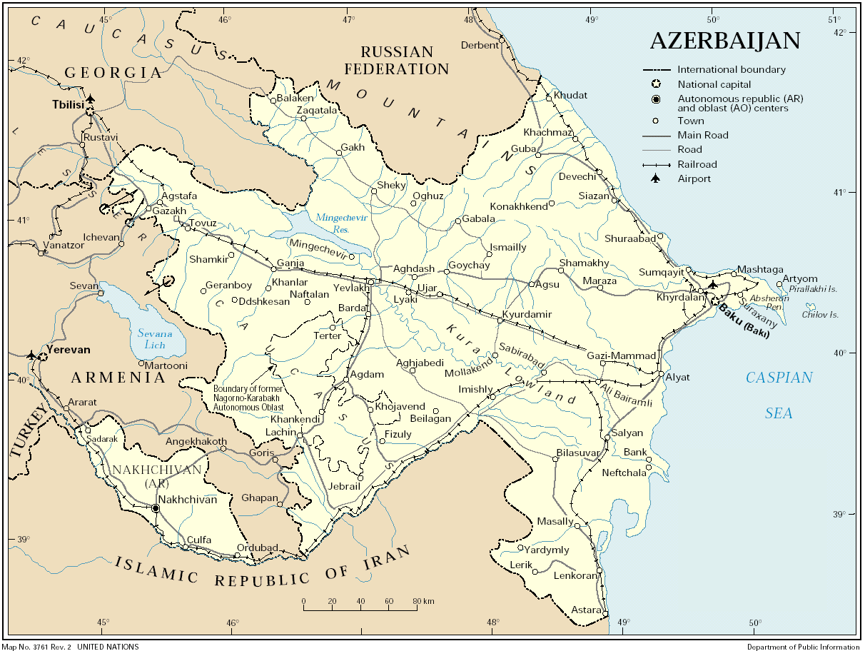
As with the highway system, one of the two main lines parallels the Caspian Sea coast from Russia to Iran before heading west to Turkey, and the other closely parallels Route M27 from Baku to the Georgian border. A major spur also parallels the highway to Xankandi. Another smaller rail line begins just west of Baku and hugs the Iranian border to provide the only rail link to Azerbaijan's Nakhichevan Autonomous Republic, isolated southwest of Armenia. Passenger service from Baku to Erevan has been suspended. In 1994 passenger service from Baku to Iran also was halted.
 Some
improvements to the network have been made in the last few years,
with EU funding, but the government estimates that 700 kilometers, or about
one-third, of the rail system are in such poor condition that reconstruction
is necessary. Much of the system has speed restrictions because of the
poor conditions of the rails.
Some
improvements to the network have been made in the last few years,
with EU funding, but the government estimates that 700 kilometers, or about
one-third, of the rail system are in such poor condition that reconstruction
is necessary. Much of the system has speed restrictions because of the
poor conditions of the rails.
The network and the trains are operated by Azerbaijan State Railway (ADDY - Azerbaycan Doövlet Demir Yolu). Some investment has been made in trains recently with the consequent reflexes in the quality of services.
 From
Baku there are train connections with Tbilisi in Georgia and Derbent
in Dagestan (Russian Federation), as well as Moscow, Rostov, Kiev, Kharkiv
(Ukraine), Brest (Belarus) and other major cities in the CIS. The train
between Baku and Tibilisi, Georgia, is inexpensive, but it takes about
20 hours and the occasional bandit raid and frequent burglaries make it
less than completely safe. The train stops twice at the border - long delays
are routine on both sides. Expect to pay the price of your ticket again
at the border as a bribe. A luxury train also runs to Tblisi: the "Silk
Road Express", tickets start at 200 Euros, round-trip. Fares include sleeping
compartments, dinner and a full breakfast in the train's restaurant car.
From
Baku there are train connections with Tbilisi in Georgia and Derbent
in Dagestan (Russian Federation), as well as Moscow, Rostov, Kiev, Kharkiv
(Ukraine), Brest (Belarus) and other major cities in the CIS. The train
between Baku and Tibilisi, Georgia, is inexpensive, but it takes about
20 hours and the occasional bandit raid and frequent burglaries make it
less than completely safe. The train stops twice at the border - long delays
are routine on both sides. Expect to pay the price of your ticket again
at the border as a bribe. A luxury train also runs to Tblisi: the "Silk
Road Express", tickets start at 200 Euros, round-trip. Fares include sleeping
compartments, dinner and a full breakfast in the train's restaurant car.
There is a railway connecting the autonomous republic of Nakhichevan with Tabriz in Iran, but there are not yet any connections to the main part of Azerbaijan.
Call Baku Railway station on 982039 or e-mail ADDY at info@addy.gov.az.
 The
overnight train services come in 3 classes:
The
overnight train services come in 3 classes:
| Roads:
- total: 57,770 km - paved: 54,188 km - unpaved: 3,582 km (1995 est.)... .................... .................. .......... .. ... . . ... . ... . .. .. ... . . . . . . . . . . |
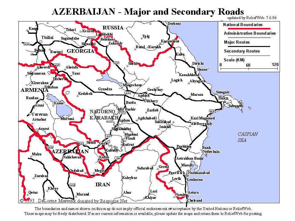 |
 All
major towns have a paved road connection with one of the principal routes.
An extensive intercity bus service is the primary mode of intercity travel.
Maintenance of the system has deteriorated since independence in 1991,
however, and one study estimated that 60 percent of the main highways were
in bad condition, resulting in excessive wear on vehicles and tires and
in poor fuel consumption. Therefore 4-wheel-drive vehicles are recommended
for journeys into the mountains, e.g. west of Quba. Traffic drives on the
right. (See
driving).
All
major towns have a paved road connection with one of the principal routes.
An extensive intercity bus service is the primary mode of intercity travel.
Maintenance of the system has deteriorated since independence in 1991,
however, and one study estimated that 60 percent of the main highways were
in bad condition, resulting in excessive wear on vehicles and tires and
in poor fuel consumption. Therefore 4-wheel-drive vehicles are recommended
for journeys into the mountains, e.g. west of Quba. Traffic drives on the
right. (See
driving).
You can take buses from Baku to
the major cities in Azerbaijan as well as the neghbouring countries (e.g
Derbent in Dagestan, Tehran in Iran, Istanbul in Turkey and Tblisi in Georgia).
The bus station is on Izmir av., tel. 388581.

|
Shipping services operate regularly from Baku across the Caspian Sea to Turkmenbashy (formerly Krasnovodsk) in Turkmenistan and to Bandar Anzali and Bandar Nowshar in Iran. The boats to Turkmenbashy take about 300 passengers on a 12 hour voyage and sail on average three times a week. Winter storms may disrupt these services. Call Baku sea port on 930268.
 Although
situated at an excellent natural harbour, Baku has not developed into a
major international port because of its location on the landlocked Caspian
Sea. The port serves mostly as a transshipment point for goods (primarily
petroleum products and lumber) crossing the Caspian Sea and destined for
places to the west, or for passenger service to ports on the eastern or
southern shores of the Caspian Sea.
Although
situated at an excellent natural harbour, Baku has not developed into a
major international port because of its location on the landlocked Caspian
Sea. The port serves mostly as a transshipment point for goods (primarily
petroleum products and lumber) crossing the Caspian Sea and destined for
places to the west, or for passenger service to ports on the eastern or
southern shores of the Caspian Sea.
The port has seventeen berths, of which five are dedicated for transport of crude oil and petroleum products, two are used for passengers, and the remaining ten handle timber or other cargo. The port can accommodate ships up to 12,000 tons, and its facilities include portal cranes, tugboats, and equipment for handling petroleum and petroleum products. The port area has 10,000 square meters of covered storage and 28,700 square meters of open storage.
 Merchant
marine:
Merchant
marine:
- total: 54 ships
(1,000 GRT or over) totaling 246,051 GRT/306,756 DWT
- ships by type:
cargo 12, petroleum tanker 40, roll on/roll off 2 (2002 est.)
Pipelines: crude oil 1,130 km; petroleum products 630 km; natural gas 1,240 km
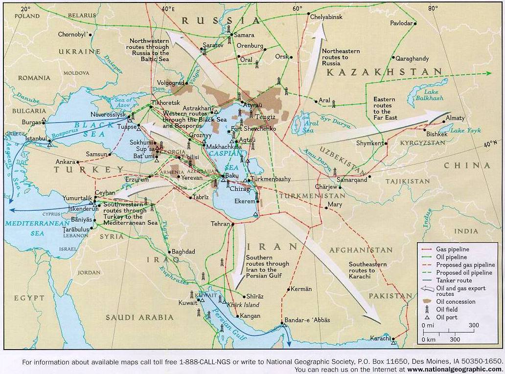
Pipeline Map |
Baku is the centre of a major oil- and gas-producing region, and major long-distance pipelines radiate from the region's oil fields to all neighboring areas. Pipelines are generally highcapacity lines and have diameters of either 1,020 or 1,220 millimeters. The main petroleum pipeline was completed in 2005 under American pressure to limit Russian and Iranian power in the area. It runs from Baku via Tblissi to Ceyhan in Turkey, therefore the acronym BTC. It made partly obsolete the old Soviet pipeline pumping crude oil from the onshore and offshore Caspian fields near Baku west across Azerbaijan and Georgia to the port of Batumi, where the oil is either exported in its crude form or processed at Batumi's refinery. Two natural gas lines parallel the old petroleum line as far as Tbilisi, where they turn north across the Caucasus Mountains to join the grid of natural gas pipelines that supply cities throughout Russia and Eastern Europe.

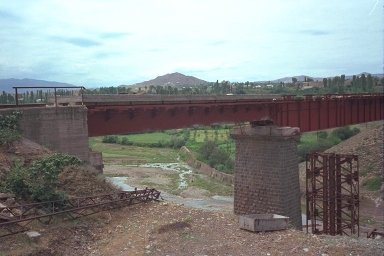
Batumi: Azeri oil arriving by rail |
As seen with the construction of pipeline to Ceyhan in Turkey, the routes for new pipelines are one of the great decisions and debates for the area, with geo-political considerations becoming heavier than either economical or technical criteria. The US, Russia, Turkey, Iran, Georgia... all try to influence decisions on the transportation of fossil fuels from Azerbaijan.
Airports: 52 (2002)
 Airports
- with paved runways:
Airports
- with paved runways:
- total: 9
- 2,438 to 3,047
m: 5
- 1,524 to 2,437
m: 4 (2002)
Baku airport
Airports - with unpaved
runways:
- 1,524 to 2,437
m: 7
- 914 to 1,523 m:
8
- under 914 m: 28
(2002)
TRACECA
 Baku
is poised to become a major regional transportation and communications
hub for the Trans-Caucasus and Central Asian republics. The TRACECA Programme
(Transport System Europe-Caucasus-Asia, informally known as the Great Silk
Road) was launched by the European Union (EU) in 1993, and encourages the
development of a transport corridor on an East-West axis from Central Asia
through the Caucasus, across the Black Sea, to Europe. In 1998 twelve nations
signed a multilateral agreement known as the Baku Declaration to develop
the transport corridor through closer economic integration, rehabilitation
and development of new transportation infrastructure, and by fostering
stability and trust in the region. The corridor includes all forms of transport.
Baku
is poised to become a major regional transportation and communications
hub for the Trans-Caucasus and Central Asian republics. The TRACECA Programme
(Transport System Europe-Caucasus-Asia, informally known as the Great Silk
Road) was launched by the European Union (EU) in 1993, and encourages the
development of a transport corridor on an East-West axis from Central Asia
through the Caucasus, across the Black Sea, to Europe. In 1998 twelve nations
signed a multilateral agreement known as the Baku Declaration to develop
the transport corridor through closer economic integration, rehabilitation
and development of new transportation infrastructure, and by fostering
stability and trust in the region. The corridor includes all forms of transport.
(sources: CIA, Library of
Congress, Britannica, EIA)
| see also: urban transportation in Baku, airport, maps, driving, images, summary, places |
| A to Z of Azerbaijan / A dan Z ye Azerbaycan |
www.azerb.com
|